Well, projects are now over. My presentation went very well, and it was cool to see everything my classmates were able to accomplish. I was very impressed! After presentations were over, I had my defense of the project with Dr. Pankratz and Dr. McVey. We talked more about the code and ways I implemented things. Overall, they were very happy with the progress I was able to achieve on my project. Now, all that's left to do is consolidate everything about my project into a binder to turn in. I cannot believe the semester/project are over. I've had a lot of fun learning and doing this project, and I'm thankful for the four great years I've had at St. Norbert. I now look forward to the future, where I will begin working with West Bend Mutual Insurance as a Configuration Developer. I am very excited to see everything this opportunity brings.
|
With four days until I present, and only two until my classmates start presenting, I'm very much looking forward to showing off the work I've done, as well as checking out what my classmates have accomplished. My presentation for Thursday is nearly complete, and I'm a bit nervous as I want everything to run smoothly. But, overall, I'm quite ready, and this week I am going to focus on making my presentation the best it can be.
This past week I received my presentation date, which will be Thursday April 30. This means I have about 10 days to finalize my project. I am a bit nervous for the presentation, as I want everything to go smoothly, but I am also very excited.
With my project being done, I know need to work on documenting source code and operation documentation, as well as continue to work on my presentation. I plan on asking McVey and Pankratz to try to break my program so I can be sure I'm set to go, but I'm confident it will hold up. In the past week, I've been continually working out bugs, and after this week I should be completely done debugging. Dr. Pankratz gave me the idea a while ago of color coordinating text with the markers on the map. I previously thought that would not work, but the other day I managed to figure it out!
Dr. McVey also gave me the suggestion of highlighting the marker and its corresponding pickup or dropoff marker on the map. I like the idea, but I have been running into some issues with that. I hope to figure it out this week. Finally, I was unable to make much progress working on the website last week, but I will finish it up this week. This project is finally coming to a close, and I now have to start thinking about how I can present my project during open demo day. Since my last update, I was able to implement a test-oriented load from file feature that works great, and allows for easily populating the app. This will be great for further testing as well as my final demo. I have also found a way to better implement removing both of a customer's markers from the map/listbox, where I am no longer doing so based on name alone.
At this point, I do not think there is too much else to do. I have met all of my objectives, so that being said, I am going to conclude adding any new features. This week, I will go through my final round of bug testing, just to make sure everything works properly. I will also do some final touchups on the UI. Finally, between this week and next week, I will finish this website, putting up more pictures and information about my project. I have worked more on the alert feature, and it seems to be very solid. I have also completed the undo, which is also working very well. In addition, I've made some more small changes and fixes, such as fixing a bug with clearing the route, adding a button to use the current time when adding a optional pickup or drop off time, and repositioning the alert icon. This week, I plan to implement a load from file feature that will quickly populate the system with customers/data, which will allow for easier demos. I also want to find a better way to implement removing a customer (both markers) from the map. There is not much left to do, and I think I will be nearly done after I accomplish these few things.
I apologize for missing a weekend update, but I did not have access to my computer due to spring break. However, I have still had plenty of time to work on the project.
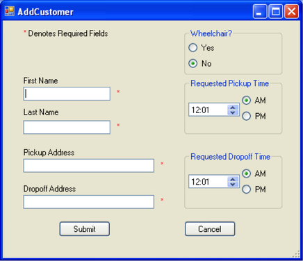
Since my last update, I have been working hard on the alert system for if the driver is in danger of missing a requested pickup or drop off time. This seems to be working quite well at this point, but I will continue to do more testing. In addition, I am currently working on an undo feature which will allow the driver to undo the last move made. This can include adding a customer, picking up/dropping off a customer, and deleting a marker. I almost have this fully implemented, and I expect to finish this within a couple days. After that is complete, I work more on finding and fixing bugs, as well as think about any small improvements that can be made. In the last week, I have made big strides in cleaning about the User Interface. I am still not completely satisfied, but it now quite a bit closer to something I would be happy with. In terms of features, I have added the ability to enter optional pickup and dropoff times for a customer. I have also added customer name and whether it is a pickup or dropoff to the "order of destinations" textbox, so it is easier for the user to understand. In addition, I have added the ability to delete a marker from the destinations textbox. I hope to add a feature that gives a friendly reminder to the user if, based on the calculated route, the driver is in danger of missing the customer's requested pickup or dropoff time. 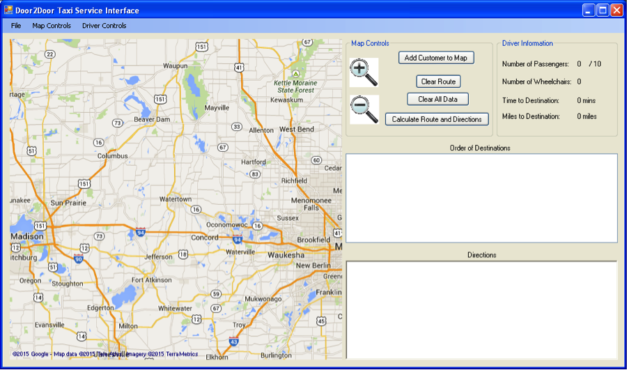
In the past week, I was able to complete the autocompleting textbox, which works very well. Unfortunately, I do not think it is possible to make markers visibly identifiable by some number or letter. This is not ideal, but having tooltips on each marker will still work well, I think. In addition, I've decided to switch from using one text file that stores all information entered to two separate file, one for locations, and one for name and a wheelchair bool. This is more of a database approach, and will be much cleaner as if the name or place already exists, it will not be written to the files. I've also been working more on the User Interface. I am in the process of making it as clean as possible, and I think I am going to remove many buttons in favor of using a menu strip.
Since last week, I met with Dr. McVey to get another perspective on my project, and she had a few good suggestions. I have since added validation when entering information for a customer. I also plan on implementing autocompleting text boxes for new customers, as well as making it easy to identify what markers belong to which customers on the map. Later on, I want to have some sort of icon key. I hope to get the text boxes and identifiable markers implemented this week.
In the past week, I've made quite a lot of progress on the GMap side of the project. I have rethought the process for adding destinations by using a customer class with data entered on a different form. These customers are then stored in a database. I am still working out how to effectively use all of this information, however.
In the past week, I've accomplished quite a bit in adding GMap features into my application. The documentation was not quite as plentiful as I first thought, but I was able to find things eventually with some digging. So far, I've implemented the ability to put customer locations on the map, show and reorder the route to take to them all, as well as the ability to show directions, route time, and distance (in miles). In the next week, I am going to work on implementing the more taxi-specific features of the app, such as picking up and dropping off customers.
Since my last entry, I took a few days to think and plan out what I needed to do for my project. Towards the end of this past week, I found a way to implement Google Maps into a C# application called GMaps. I have been playing around with this api for a little while, and there seems to be many things it can do. The documentation of it has been very helpful.
So Today Dr. Pankratz informed me which project I would have for the semester, which is the Door2Door taxi service. Dr. Pankratz told me the idea behind the project should be a theoretical view for drivers of the service, so they can see what routes to take if passengers are picked up and dropped off. It should also provide information such as miles to the destination, and how long that route would take. The project needs to have some sort of map, which updates based on the state of the pick up. My first thought was to use a Google Maps plugin, or something similar if available. I've decided to take the day to begin brainstorming a plan.
|
Author |
 RSS Feed
